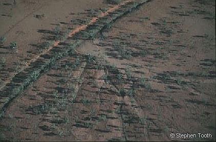
Fig. 1 Marshall R., central Australia
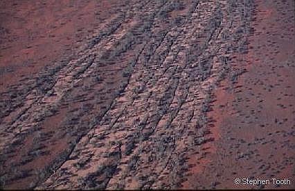
Fig. 2 Marshall R., central Australia
Stephen Tooth’s website
Welcome to my personal website. The following pages contain a brief biographical background, some information about my current research and teaching interests, and a list of publications and recent conference abstracts. Please feel free to e-mail me with any queries, questions, comments etc. at set@aber.ac.uk
Background
I graduated with a BSc Honours degree in Geography from the University of Southampton, England, and obtained my PhD from the University of Wollongong, Australia. My doctoral research focused on the morphology, sedimentology and late Quaternary history of ephemeral rivers in arid central Australia. In 1998, following a brief spell as a temporary lecturer in the Department of Geography, University of Nottingham, I joined the Department of Geology, University of the Witwatersrand, South Africa, as a FRD (formerly NRF) Research Fellow. My postdoctoral research focused on the morphology, sedimentology and Cenozoic development of rivers and riverine landscapes across southern Africa. In April 2000, I started a lectureship in the Institute of Geography and Earth Sciences, University of Wales, Aberystwyth and joined the River Basin Dynamics and Hydrology Research Group.
Research interests
Current research interests include fluvial geomorphology, and the geomorphology and sedimentology of drylands, with particular emphasis on Australia and southern Africa. For a list of references and recent conference abstracts, go to:
For a general guide to the Klip River wetlands, South Africa, go to:
Currently, I am a Member and Trustee of the Executive Committee of the British Society for Geomorphology (incorporating the BGRG). This is the professional organisation for British geomorphologists and provides a community and services for those involved in research, teaching and consultancy in geomorphology, both in the UK and overseas. For more information on the BSG and its activities, go to:
The following provides some brief information on aspects of my dryland river research:
Introduction
‘Drylands’ is a collective term for the hyper-arid, arid, semi-arid and dry-subhumid regions of the world, which cover almost 50% of the global land area and contain almost 20% of the global population. Despite the low annual rainfall totals, many dryland regions support very large, albeit often infrequently-flowing, rivers. Ongoing investigations of the geomorphology and sedimentology of rivers in central Australia and southern Africa is significantly enhancing our appreciation of the diversity of river process and form in drylands, and contributing to a greater understanding of river behaviour in response to changing environmental conditions. These findings have relevance for the management of future adjustments to dryland rivers resulting from climatic or land-use changes. Research into dryland rivers is focusing on a number of related themes:
• Anabranching rivers
• Floodouts
• Wetlands in drylands
• Donga (gully) erosion
• Bedrock-influenced rivers
• Palaeoenvironmental change
Anabranching rivers
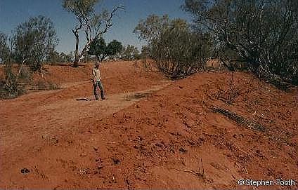
Rivers in central Australia are commonly dry and only rarely flow. To exploit moisture contained in subsurface sands, trees often establish along the channel beds. These are able to withstand submergence during the infrequent floods, thus resulting in flow diversion and sediment deposition. Sediment accumulating in the lee of the trees (Fig. 1) is colonised by younger trees, which encourages further deposition, and ultimately results in the growth of long, narrow ridges or islands. This process turns a single channel, initially obstructed with a dense stand of trees, into a number of smaller, narrower channels (Fig. 2). This unusual style of river is termed anabranching.
|
Fig. 1 Marshall R., central Australia |
Fig. 2 Marshall R., central Australia |
Floodouts
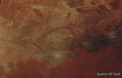
Many dryland rivers undergo marked downstream changes owing to factors such as infrequent floods, losses of floodwater through seepage into the channel bed and banks, and typically few tributary inflows beyond the headwaters. In many instances in central Australia, channels decrease in size downstream and end in floodouts, with the rare floodwaters spilling across broad unchannelled surfaces. The lower reaches of the channels and the floodouts are characterised by a range of active and relic features, such as splays (Fig. 3), waterholes, aeolian dunes and old channels (Fig. 4). Following the rare floods, these areas support a lush growth of grasses and forbs.
|
Fig. 3 Sandover-Bundey R., central Australia |
Fig. 4 Sandover R., central Australia |
Wetlands in drylands
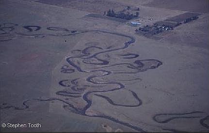
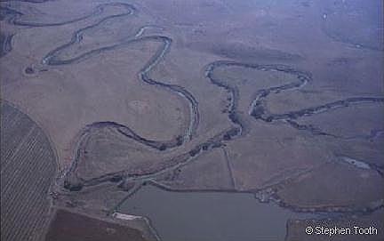
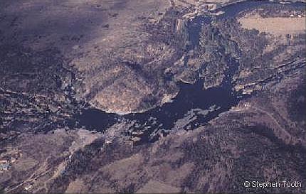
A large number of rivers in southern Africa meander within extensive floodplains. Despite strong seasonal water deficits, these floodplains commonly host substantial wetlands which are sustained by summer floods (Fig. 5). Meandering rivers commonly occur upstream of resistant rock outcrops or geological faults, and are naturally dynamic, with processes such as point bar deposition, cutoff formation and channel abandonment resulting in an assemblage of fluvial landforms (Fig. 6). This creates a mosaic of habitats of varying age, thus contributing to high ecological diversity. For more images from the Klip River wetlands, go to: klip river wetlands.doc
|
Fig. 5 Jao-Boro R., Okavango Delta, Botswana |
Fig. 6 Klip R., eastern South Africa |
Donga (gully) erosion
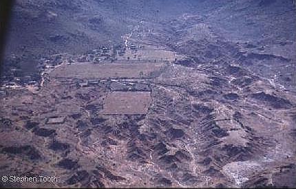
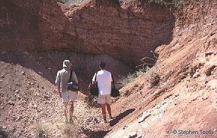
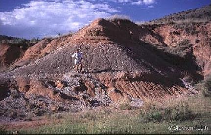
Many river terraces and alluvial fans in southern Africa are currently being eroded by dongas (gullies) (Fig. 7). Donga erosion has commonly been attributed to poor land management, but in some cases is a natural process closely related to river bed erosion at the foot of the terrace or fan. Where the river bed is currently eroding downwards, banks have become steeper and dongas have eroded headwards from the banks into the neighbouring terraces and fans. Evidence of former dongas, which have been buried by sediment but are now re-exposed by erosion (Fig. 8), shows that this process has occurred repeatedly in the past.
|
Fig. 7 Maandagshoek fan, northeastern South Africa |
Fig. 8 Maandagshoek fan, northeastern South Africa |
Bedrock-influenced rivers
Many southern African rivers are today actively eroding downwards, such that their beds are positioned on bedrock. In these instances, local geology can exert a strong influence on river forms. Where the outcropping bedrock is readily erodible (e.g. sandstone, shale), rivers have carved wide valleys. In contrast, where the bedrock is highly resistant (e.g. dolerite, quartzite, granite), valleys are much narrower, and the rivers follow joints or fractures in the rock. This commonly results in right-angled river bends (Fig. 9) or in channels dividing around bedrock islands (bedrock anabranching) (Fig. 10).
|
Fig. 9 Klip R, eastern South Africa |
Fig. 10 Vaal R., eastern South Africa |
Palaeoenvironmental change
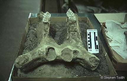
Donga erosion provides exposure of the sediment layers underlying river terraces and alluvial fans. Some of these layers have weathered to form soils (Fig. 11) while others are largely unweathered. In addition, many layers contain mammalian (including hominid) fossils and stone tools (Fig. 12). These are being investigated as part of a research effort involving geologists, archaeologists and palaeoanthropologists from the UK, South Africa and the US. The succession of sediments of different weathering status and changes in fossil content indicate that past climates of southern Africa have fluctuated between conditions both more humid and more arid than at present.
|
Fig. 11 Maandagshoek fan, northeastern South Africa |
Fig. 12 Hippopotamus lower jaw recovered from river terrace |
Other research themes (see recent conference abstracts) include:
For further information about dryland rivers, go to the website maintained by Dr Colin North at the University of Aberdeen which is intended to foster communication and discussion between researchers interested in dryland rivers:
Teaching interests
Presently, I teach a 3rd year lecture course entitled ‘Dryland Geomorphology’. This course is designed to enable students to gain a factual and conceptual understanding of the major landforms and processes in the world’s extensive dryland regions, including an appreciation of how these forms and processes respond to environmental changes. The module stands alone as a component in the undergraduate course, but has links with other modules, particularly those dealing with environmental change. The module includes both lectures and a seminar series. Lectures involve the extensive use of slides from a wide range of drylands and lecture notes and supporting material are posted on a website (available to registered UWA students). The emphasis is on research-led teaching, and students are encouraged to read critically the rapidly-expanding literature on drylands.
I also teach a 2nd year course entitled ‘Dynamics of Hydrological Systems’ in which I cover the basics of hydrodynamics, and contribute to 'Earth Resources' (formerly 'Laboratory Techniques') in which I cover methods for the physical analysis of clastic sediments. A presentation that outlines my philosophy and approach to one of the practicals that forms part of this course, and the teaching developments undertaken, is provided at the following link:
Other teaching commitments include tutorials, supervising final year dissertation students, and contributing to a week-long residential fieldcourse in Ireland which looks at resource use and the associated problems of environmental management.
I am co-supervisor of a PhD student, Helena Rodnight, who is developing luminescence procedures for dating fluvial sediment in South African floodplain wetlands. I also co-supervised another PhD student, Phillippa Noble (completed 2004), who looked at the geomorphic and sedimentary response of dryland rivers in southeast Crete to late Quaternary environmental changes. The 4th International Palaeoflood Workshop was held in Crete in June 2007, and included field visits to some of Phillippa's sites. For more information about this workshop (to be updated in the autumn with images from the meeting), go to:
Go to:
Return to:
River Basin Dynamics and Hydrology Research Group
Disclaimer: The information provided on this and other pages by me, Stephen Tooth (set@aber.ac.uk) is under my own personal responsibility and not that of the University of Wales, Aberystwyth. Similarly, any opinions expressed are my own and in no way are to be taken as those of UWA.
Last updated 05/07/07